RECENTLY VIEWED
Skip to main content

DK Hardware Professional Tax Exempt? Net 30? - DK Net Terms
Roll over image to zoom in
30 Days Easy Return. We are the largest supplier of the most adaptable, personalized hardware in the industry. We work hard to ensure you're satisfied with our products.
WARNING: This Product May Contain Chemicals Known to the State of California to Cause Cancer or Reproductive Harm. To Learn More Visit P65Warnings.ca.gov
Features
Type
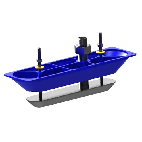
Thru-Hull , Fairing Block
Material
Stainless Steel
Transmit Power
Max RMS: 500 Watts
Sonar
Down Imaging , Side Imaging , 3D Imaging
Deadrise Angle
Up to 24 Degree
Beam
58 Degrees at 455kHz
Mount Type
Module: Surface , Transducer: Thru Hull
Waterproof
Waterproof
Maximum Depth
300 Feet (Downscan) , 600 Feet (Sidescan)
Product Overview
SIMRAD and Lowrance StructureScan 3D allows boaters to see fish, structure and bottom contour in a stunning three-dimensional view. StructureScan 3D imaging scans underwater terrain and structure to create a high-resolution, 180-degree, three-dimensional view beneath your boat. With this unique imaging view, you gain a better understanding of where objects and structure are located in relation to their boat. The picture-like, three-dimensional views are displayed on the SIMRAD EVO 2 & 3 series and the Lowrance HDS series of sonar/chartplotters, when used in combination with the StructureScan 3D single or dual transducer thru-hull and module. StructureScan 3D StructureScan 3D is powered by a multi-beam sonar technology that produces revealing images with stunning detail by converting scans of underwater terrain and fish-holding structure into high-resolution, 180-degree, three-dimensional views. Easy-to-Understand Sonar Images View 3D images from any angle with ScanTrack pan-tilt-rotate control using on-screen touch commands and easy-to-use, preset viewing positions. Find Key Fishing Areas Faster StructureScan 3D allows anglers to more easily understand where fish and fish-holding structure are located in relation to their boat. By slowly idling over a potential fishing area with the wide, 180-degree scanning range, anglers can quickly search for key areas and cover such as abrupt depth changes, points, ditches, rockpiles, brushpiles, weedbeds standing timber, wrecks and more. Unrivaled SideScan Image Clarity To ensure the clearest possible SideScan views, the StructureScan 3D transducer design has been enhanced with an increased number of sensors for greater imaging performance. High Definition (HD) and Super-Wide 3D Scanning The contours below the water's surface can be shown to the sides of the boat up to 600 feet port and starboard with incredibly detailed, high-definition views. StructureScan 3D provides multiple views, including two-dimensional DownScan Imaging and StructureScan HD, and the new, realistic three-dimensional views. Using preset virtual point-of-view angles or ScanTrack pan-tilt-rotate control mode, you can adjust the view and perspective beneath your boat. Combine custom HD and 3D views to increase your understanding of how fish relate to cover and to search fishing areas more effectively. Leading Edge Scanning Reference The Leading Edge scanning reference provides a clear graphical illustration of sonar beams as they intersect with bottom contours. The depth and range of the most recently scanned area are shown as red fan-shaped markers directly under the boat. Leading Edge also includes a depth scale that shows greater depth detail as you zoom in, giving you a better sense of target depth. SelectScan Target Identification SelectScan automatically shades fish-holding cover and suspended targets in a color that contrasts the selected color palette, making target identification quicker and easier than ever before. Vertical Enhancement Control Vertical Enhancement is a user-selectable scale that will apply on-screen emphasis to vertical drops and crucial depth contour changes, making them easier to identify relative to the surrounding underwater terrain. Vertical Enhancement makes even the slightest depth changes more visible. Waypoint Overlay Revisiting fishing areas, structure and other underwater features is easy with the Waypoint Overlay feature. Use the waypoint keypad to save a waypoint at the boat location, or switch to cursor mode, and save a waypoint over specific targets, baitfish or cover. Automatic 3D Image Settings Fine-tuned 3D image settings are set by your HDS Gen 3 default configuration and StructureScan 3D Module. Adjustments can be made to Surface Clarity and Contrast settings using the on-screen slider-bar. Surface Clarity reduces on-screen surface clutter, by decreasing the sensitivity of the receiver near the surface. Contrast lightens/darkens the color palette to make fish and structure easier to see.